en GPS Tab5 Scaling (bubbles)
- Stefanie Schröder (Unlicensed)
- Johannes Lentzsch
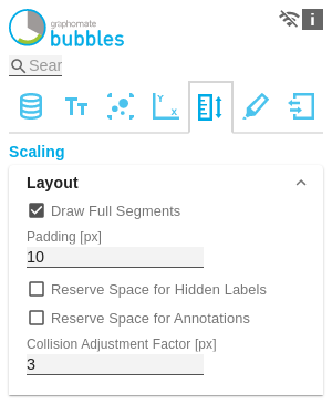
LayoutDraw Full SegmentsIf the Full Segments checkbox is activated, the scaling of the axes is selected so that all quadrants of the grid have the same size. If it is deactivated, the axes are scaled so that the available space is optimally used. However, half quadrants may be created. For optical reasons, the outer lines of the grid (Borders) at the top and right are hidden. PaddingSet a distance in [px] for the padding that surrounds the entire diagram. Reserve Space for Hidden LabelsIf Reserve Space for Hidden Labels is activated, the scaling is selected so that all bubbles including their labels fit into the diagram. This also includes labels hidden by collision. Reserve Space for AnnotationsIf Reserve Space for Annotations is activated, the distance of the axes from the edge of the component is selected so that all axis labels can be displayed. This particularly includes annotations that are displayed on the axis due to runtime interactivity and represent the value of a bubble. Collision Adjustment FactorUse the Collision Adjustment Factor to define a value in [px] that specifies by how many pixels labels may overlap each other until they are hidden by the collision logic. |
|
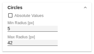
CirclesAbsolute ValuesIf this option is activated, the amount for each value of the Circle series is calculated and used as the data basis for the display. This is useful if negative values occur in the selection that should actually be displayed as positive. Min and Max Radius [px]Define the upper and lower limits for the radius of the bubbles in [px]. This means that no bubble with a radius greater or smaller than the min. or max. radius exists. |
|
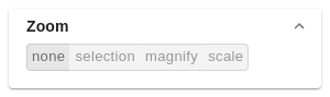
ZoomFour different zoom modes can be selected. You can choose between none, rect, magnify and scale. For more tips on 'Zoom Modi', see the 'Runtime interactivity' section in the documentation. |
|